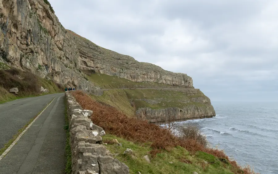
Marine Drive is the road that circles the Great Orme at roughly a hundred metres above the sea. Conwy County Borough Council calls it a five-mile toll road, open all year, with views over Anglesey and Eryri. Walkers and cyclists use it free. Cars pay. That is the whole arrangement, and it is one of the best things Llandudno has, because it gives you the headland without having to climb it.
The Great Orme guide covers the tram, the cable car, the mines and the summit. This page is the circuit at the base: how to walk it, how to drive it, how to combine it with the tramway, and why you should look at the council’s own pages before you assume the road is open.
It begins past the pier, on the North Shore, at a toll gate under the crags of the Orme. The first three and a half miles are one-way for traffic. About a mile in, St Tudno’s Road turns left for the summit and the church. The Rest and Be Thankful café sits at the halfway point with its own car park. The Great Orme Lighthouse — decommissioned, now a bed and breakfast — stands on the north side. After a great many bends the road comes out on the West Shore.
For cars that is a one-way loop from the pier to West Shore. For walkers it is a terrace around a limestone headland, tarmac the whole way, with the sea below and the country park above. The walks guide puts the full circuit at two and a half to three hours from the pier, with almost no climbing after the initial rise from town. That is the right order of magnitude. It is not a mountain day. It is not a promenade either. There are real drops.
This is the best way to use the road.
Start at either end. From the North Shore you leave the pier, pass the toll gate and have the bay, the Little Orme and then the open water on your right as the town drops away. From West Shore you start with Conwy Bay and Anglesey and finish with the hotel crescent ahead of you, which is the more satisfying arrival. Plenty of people walk it anti-clockwise from West Shore for that reason.
You are on tarmac, with a pavement for most of the way. Traffic is one-way and usually light, but it is still a road — rally cars use it on event days, and coaches come through by arrangement. Keep to the side. The wind on the north face is out of proportion to the weather on the promenade. There is no shelter until the café.
The Rest and Be Thankful is the pause. After that the lighthouse, the north cliffs, and the long drop back towards Happy Valley and the pier. Seals are often visible off the north side; the larger haul-out is at Angel Bay on the Little Orme, which is a different walk.
Cars pay a toll at the North Shore gate. Cyclists do not. The current figures, the season permit and the ways to pay — cash at the booth, or PayByPhone with a receipt to show — sit on Conwy CBC’s Marine Drive Toll Road page. They change. Do not copy a number from a blog, including an old one of ours.
A toll ticket currently also covers parking at the summit. That is the useful combination if the headland is the whole outing: pay once at the gate, turn up St Tudno’s Road, park at the top, walk the limestone, come down. Confirm that stacking on the same council page before you assume it, in case the two charges have been separated.
Taken as a piece of town planning, Marine Drive is the Victorian idea of a scenic road, cut around a headland that was already a copper mountain and a sheepwalk. It gives Llandudno a clifftop terrace the North Shore promenade cannot. On a clear day the Isle of Man sits on the horizon; Anglesey fills the west; Eryri fills the south. On a murky day you are still on a shelf above the sea, which is enough.
The North Shore start is the one visitors find, because they have just walked the pier. The West Shore start is quieter and puts the sunset side of the Orme first. If you have already been on West Shore for the evening, walking the Drive the next morning from that end is the clean continuation.
You do not have to do the whole five miles. Plenty of people walk out to the café and come back the way they came. Plenty more walk the north face only, from the toll gate to St Tudno’s Road, and then cut up to the church. The tarmac will still be there tomorrow.
The Kashmiri goats use Marine Drive as a pavement. They have been on the Orme since the nineteenth century, descended from a gift to the Mostyn family, and they are wild, large and unbothered. They stand in the road. They stand on the wall. In a hard winter they come down into the upper town and make the papers. Give them room, especially in the autumn rut. They are not a petting zoo, and they have the horns to prove it.
The cliffs below the road are a seabird site: choughs, fulmars, guillemots, razorbills, kittiwakes. The country park is a Site of Special Scientific Interest for the limestone flora as much as for the birds — wild cotoneaster that grows nowhere else in Britain, squill, orchids. You will not see the cotoneaster from a moving car. You might from a walk, if you already know what you are looking for.
Grey seals show on the water off the north side. Binoculars help. Do not scramble down.
The Drive and the tram are the two civilised ways around the Orme. They do not go to the same place, which is why they combine.
The Great Orme Tramway runs from Victoria Station on Church Walks, through the streets of the upper town, changes cars at the Halfway Station, and finishes just below the summit. Cable-hauled, 1902, original cars, seasonal — typically late March to late October. It does not run in winter. In peak season the operator wants you to book; turning up for a walk-on is how people lose an hour in a queue. Fares, hours and whether they are still cash-only at the window are the tramway’s own business. See the tramway page and the operator before you travel.
A day that uses both: tram up in the morning, walk the summit to St Tudno’s Church, drop onto Marine Drive on the north side, and follow the road round to West Shore or back to the pier. You have had the mechanical Victorian novelty, the quietest church in the town’s name, and the cliff road, and you have not had to drive any of it.
St Tudno’s Road leaves the Drive about a mile from the North Shore gate. It is the turn for the summit car park and for the church the town is named after — a small medieval building on a sixth-century site, on the northern slope, away from the café and the ski slope. Open-air services are still held in the churchyard in summer. It is a fifteen-minute walk across the turf from the summit complex, and it is the quietest place on the headland.
If you only drive the Drive and never take this turning, you have seen the cliffs and missed the point of the country park. If you only ride the tram to the summit and never drop onto the Drive, you have seen the view and missed the sea.
The summit complex is a former hotel, now a café and bar. On a clear day the list is Snowdonia, Anglesey, the Isle of Man, Blackpool Tower and the Lake District. On a more normal day it is the Orme in cloud and a cup of tea. Look up from town before you pay for a ride to the top.
Marine Drive closes. Rockfall is the usual reason. Conwy CBC has shut the North Shore end — toll gate to St Tudno’s Road, and sometimes on to the café — more than once in the last few years, to vehicles, cyclists and pedestrians together. The West Shore approach has sometimes stayed open when the pier end has not.
There is no useful guess to make from the weather in Llandudno. Check before you set out. The council posts closures on its own channels and on the Marine Drive page. If the road is shut, the tram, the cable car and the footpaths from Happy Valley and West Shore are the remaining ways onto the headland — seasonal and weather-dependent in the first two cases, open in the third.
Do not walk around a rockfall closure. The cliff is why the road is closed.