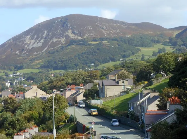
Penmaenmawr is a town on the North Wales coast between Conwy and Llanfairfechan, 8.8 km from Llandudno in a straight line. It was an important quarrying town — the name is Welsh for “Head of the Great Stone” — and quarrying is no longer a major employer. It sits on a coastal plain about 2 miles (3.2 km) long and half a mile deep facing Conwy Bay, with Puffin Island and the south-east tip of Anglesey to the north-west and the Great Orme to the north-east. The community, which includes Dwygyfylchi and Capelulo, had 4,353 people at the 2011 census; the town itself had 2,868.
The draw for a day out of Llandudno is a long pebble-and-sand beach that reviewers keep calling quiet, an inflatable aqua park on a man-made lake inland, an independent museum, and a prehistoric stone circle on the moor above. The town lies partly within Snowdonia National Park (Eryri), and Penmaenbach, the headland to the east, is the park’s most northerly tip.
Expectations matter here. The A55 Expressway bypassed the town in the 1980s, taking the old Edwardian promenade with it; since the road arrived the seaside has been separated from the town, and population and tourism have declined. A visitor to the beach in July 2025 found “nothing much to do or many shops in the town at all”.
The beach is extensive — smooth pebbles at the top, a wide expanse of sand below — and it held a Blue Flag for five years running, without saying which years. It scores 4.6 from 437 Google reviews, and quiet is the word that recurs through them.
What you get depends on the tide. A visitor in June 2025 wrote, “This is a great beach, especially when the tide is out so you can get to the sand.” One in August 2025 added a warning worth carrying into the water: “just be aware the pebbles tend to are not level so u might think the water is shallow but 3 steps ahead its deep.”
The other constant is the A55, which runs along the back of the shore. A visitor in July 2025 was even-handed about it: “the trees block out a lot of the noise, and when you get close to the water you can’t hear it…but it’s not super relaxing otherwise.”
The promenade has a café, toilets, a paddling pool and play area and a skate park; the sailing club is on the front, the bowling club opposite its entrance near the railway station, and an underpass links the shore to the town. Parking has been free, though an April 2025 review noted “there is a new car park and still no parking restrictions in place”. The toilets now charge, and dog rules vary from section to section — a June 2025 visitor advised checking “the map before letting your dog loose.”
Sblash Aqua Park, inland on Graiglwyd Road, is the highest-rated place in the town in this research at 4.9 from 215 Google reviews. It is an inflatable obstacle course on water, with wetsuits, helmets, buoyancy aids and grippy socks provided, lifeguards on the bank and on paddleboards, and sessions of about an hour. A visitor in September 2024 described the setting: “The lake it is in is man made and deep enough that you do not touch the bottom even when jumping off the tallest item.”
Praise is close to unanimous, with three caveats running through it. It is small — “It’s not too big, but my kids enjoyed it loads,” wrote a visitor in July 2026. The changing facilities are the one consistent complaint, a May 2026 visitor wanting “a solid, lockable door, rather then a shower curtain”. And it takes booking and finding: another visitor that month praised the “great setting (after finding it)”.
Penmaenmawr Museum, Amgueddfa, is an independent museum in the Old Post Office at Pant yr Afon, rated 4.8 from 66 Google reviews, though this research carries no visitor account of what is inside. Eden Hall, a small historic garden, is near the town centre.
Quarrying of diorite began at Penmaenan in 1830. The competing Graiglwyd and “Old” quarries were amalgamated by 1888 under Colonel Darbishire, and in 1911 the operations merged with the quarries at Trefor to form the Penmaenmawr & Welsh Granite Co. Early output was setts and paving, with crushed rock for railway ballast taking over from 1881. By the early twentieth century about 1,000 men worked in the quarry and its workshops, in a community that was close-knit and almost entirely Welsh-speaking; they were expected to walk up to the summit workings in all weathers and lost pay if they could not reach the top. Stone went down on self-acting inclines and a 3-foot gauge tramway to jetties, and out by ship to Liverpool and to European ports including Hamburg. Ships loaded at the Darbishire jetty until 1976, and the Network Rail ballast contract was lost in 2008.
The mountain records all of it. The summit stood at 1,500 feet (460 m) before quarrying reduced it, and the rounded top is gone, leaving the flat one visible today. Braich-y-Dinas, one of the largest Iron Age hillforts in Europe, stood up there; nothing remains, the last of it obliterated by quarrying in the 1920s. In between, the town had a spell as a resort for the well-to-do, helped along by William Ewart Gladstone, who holidayed here eleven times between 1855 and 1896.
The uplands hold older industry still. On the west slopes of Cwm Graiglwyd stood one of the most important polished stone axe factories in Europe, alongside Langdale in the Lake District and Tievebulliagh in County Antrim; axes from here were exported 5,000 years ago and have been found as far away as Cornwall and south-east England.
The circle is Meini Hirion, known in English as the Druid’s Circle, where excavation found the cremated remains of children, and a prehistoric trackway from Bwlch-y-ddeufaen to Conwy runs past it. Google lists the site as Cefn Coch Stone Circle, which a visitor in January 2025 disputed: “The site listed here is NOT Cefn Goch. Cefn Goch is a burial mound a little ways down the path from here.” It rates 4.7 from 131 Google reviews.
Walkers rate it highly. A January 2026 visitor called it “Scenic, easy hike. It’s a moderate climb. There is a clear path all the way there so no getting lost,” and met wild ponies on the way. Drivers do not. A February 2026 visitor gave one star largely for the approach: “Google maps takes you down what I recall as the worst road I’ve ever been through. 20% Incline”. In July 2025 another reported “a sign not allowing cars to reach the end of the road, as indicated by Google maps.” A December 2022 visitor described the alternative: “We parked up on Mountain Lane (to the East of the site) where there is space off the road for a couple of cars before the gate, and then about a 30 min walk from there”. There is more than one circle up there, and the main one, in the words of an August 2020 review, “is up above the track, and not easily visible unless you go off the track.”
The bus is the direct link. Arriva Buses Wales routes 5 and 5D run every 15 minutes between Caernarfon and Llandudno; Llew Jones runs the Conwy Clipa service 75 between Llanfairfechan and Llandudno; and Padarn Bus has introduced a Saturday X2 running direct between Penmaenmawr and Llandudno eastbound.
Penmaenmawr has its own station, with an hourly Transport for Wales service to Holyhead and Chester on the North Wales Coast Line. It is not a direct trip from Llandudno, though: the timetable data here lists 31 stations reachable from Llandudno without changing on a weekday and Penmaenmawr is not among them, so the train means a change, with Llandudno Junction the interchange this research points to and Llandudno’s most frequent link at 66 trains a day.
By road the town is on the A55, with access at Junction 16 and at 16A, and a mountain route through Capelulo links it to Conwy over the Sychnant Pass. By bike, the research describes a largely traffic-free, family-friendly 24-mile round trip from Llandudno to Llanfairfechan on National Cycle Network Route 5, which runs along this coast; a visitor at the beach in July 2018 noted “a cycle path parallel to the beach with easy cycle access towards both Conwy and Bangor.”
The village and what is around it, at walking scale.
Open any of them in Google Maps for directions and current opening.
Want live prices and dates? GetYourGuide's booking widget shows them, and sets their cookies in your browser when it loads.
Background on Penmaenmawr draws on its Wikipedia article, text there being available under CC BY-SA 4.0.