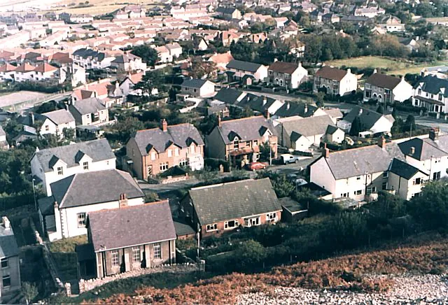
Dwygyfylchi is a village on the North Wales coast, boxed in between two headlands and backed by an arc of hills. It is part of the community of Penmaenmawr, which had a population of 4,353; the electoral ward of Capelulo, which takes in Dwygyfylchi, had 1,485 people in 2011. Roughly half the village forms the most northern tip of the Snowdonia National Park, which is the short way of saying the mountains begin at the back gardens.
The distance from Llandudno is 6.8 km in a straight line, west along the coast..
Almost everything worth the trip is inland and uphill — a conservation centre in the woods at the head of the pass, Iron Age forts on the ridge above, a stream running down through a wooded glen — with one piece of the story out on the sands offshore.
Half a mile south-east of the main village lies Capelulo, the original settlement, at the foot of the pass. The old road crosses Bwlch Sychnant, and the mountain route through Capelulo is still the link to Conwy.
The names carry the history. Dwygyfylchi comes from the Welsh dwy, “two”, and cyfylchi, a word used almost exclusively in place names meaning a “circular fortress”; it was first recorded as “Dwykyvelchy” in 1287, and there are several old fortifications on the hills around. Capelulo takes its name from Saint Ulo and is reputed to have been the site of an early medieval church.
Behind the village the hills run east to west: Yr Allt Wen directly above Dwygyfylchi, then Bwlch Sychnant and Pen-sychnant at Capelulo, the rounded hill of Foel Lys, Gwddw Glas — Green Gorge — and Bryn Derwydd. The coastal plain below is nearly divided by Trwyn-yr-Wylfa, which marks the boundary between the Hen Bentra, or Old Village, of Dwygyfylchi and Capelulo to the east and Pant-yr-afon and Penmaenan to the west.
The larger of the two local rivers is the Afon Gyrrach, which runs about 4 miles (6.4 km) from the northern slopes of Tal-y-Fan to the sea near Penmaenbach. On the way it passes through Nant Ddaear-y-llwynog — the Fairy Glen — and then through the old villages of Dwygyfylchi and Capelulo, so glen and settlements sit on one continuous line of water.
Pensychnant Conservation Centre stands on Sychnant Pass Road, and at the top of the pass is Pen Sychnant Nature Reserve, 12 acres (5 ha) of mature shrubs and woodland. The centre scores 4.6 from 134 Google reviews, and those reviews are less uniform than the figure suggests.
The praise is consistent: an arts and crafts house run by a charity, woodland walks, art exhibitions, and tea and cake. A visitor in March 2026 wrote, “Open at the weekends for teas, coffee and cake.” One in August 2025 described a short walk “through a wild patch of woodland which has been sensitively managed with some dead standing timber.” Dogs are not permitted anywhere on the site, a rule one visitor in March 2025 endorsed on the grounds of “the fragility of the natural habitat here.”
The complaints are practical and they recur. Opening is not guaranteed — a visitor in August 2025 found the house shut and nobody about during hours the website had advertised, and one in May 2025 reported that “The building was closed but I walked around the nature trail so cannot really give a full rating.” The ground is rough: a visitor in July 2022 warned that “Some of the tracks are overgrown and have nettles and thorns in close proximity,” adding “Not suitable for wheelchairs or disabled. Stout footwear needed and shorts not recommended.” One in March 2021 put it as “Definitely not wheelchair or buggy friendly but if your steady on a walking stick then I think it would be okay.”
Not everyone warms to it. A visitor in June 2025 called the whole thing a “Really bizarre and unwelcoming experience”, found that nobody acknowledged them, and was pointed at something that “wasn’t really a path and was quite dangerous”. A supporter in July 2023 was blunt about the building itself: “it will be lost if money is not put into it.”
The surrounding landscape is dotted with palaeolithic, mesolithic, neolithic, Bronze Age and Iron Age structures — cromlechs, standing stones, stone circles and hill forts. The 1868 National Gazetteer recorded a great number of antiquities here, “cromlechs and single upright stones, the remains of a British camp, with ditches and ramparts”.
Two forts matter. Caer Seion sits at the summit of Conwy mountain, at the eastern end of the ridge. Braich-y-Dinas, at the summit of Penmaenmawr, was one of the largest Iron Age hill forts in Europe, comparable with Tre’r Ceiri on the Llŷn peninsula — but there is nothing to see, because the last remnants were destroyed in the 1920s.
Offshore, about a mile north of Dwygyfylchi, is Llys Helig. The legend makes it the palace of Prince Helig ap Glanawg, a 6th-century prince said to have held the land between the Great Orme’s Head and the Menai Strait, land later inundated by the sea: the drowned kingdom. The remains are said to be visible at exceptionally low tides, near the Conwy channel. Two things temper the story. The earliest known use of the name Llys Helig for the rock formation is the Halliwell Manuscript, believed to date to around the beginning of the 15th century, nine centuries after the prince; and the formation is a glacial moraine left by the ice ages. South of it is a fish weir that tradition dates to the beginning of the 6th century and that was used until the early 20th century.
Dwygyfylchi is small, and the list of amenities is short. Penmaenmawr Golf Club has a 9-hole course between Dwygyfylchi and Capelulo, with Dwygyfylchi Bowling Club nearby, and Penmaenmawr Phoenix F.C. of the Clwyd Premier League plays between Dwygyfylchi and Penmaenmawr. Dwygyfylchi Beach and Penmaenbach Beach both appear on Google as attractions, but on six and five reviews respectively — too few to read anything into.
The parish church, dedicated to Saint Gwynin or Gwynan, was built between 1888 and 1889. Its pews were made from the roof timbers of the 1760 church it replaced, whose foundation stone was kept and mounted on the vestry wall, where it can still be seen. The patronal festival is 31 December.
The name is the awkward part. Dwygyfylchi was an ancient parish, made a local government district in 1866; in 1890 the district was renamed from Dwygyfylchi to Penmaenmawr, in recognition that Penmaenmawr had become its largest settlement. The civil parish kept the older name until 1974, when civil parishes were abolished in Wales and the area became the community of Penmaenmawr. Much of what is signposted, addressed or listed as Penmaenmawr is therefore here.
By bus this is straightforward. Arriva Buses Wales runs services 5 and X5 every 15 minutes between Caernarfon and Llandudno, and it is the 5 you want: eastbound, service 5 serves St Gwynan’s for Dwygyfylchi and Craig-y-don, while the X5 goes by Deganwy and Maesdu instead. Westbound, both run on to Bangor and Y Felinheli. Llew Jones runs the Conwy Clipa service 75 between Llanfairfechan and Llandudno, and Padarn Bus operates a Saturday service, the X2, direct from Penmaenmawr eastbound to Llandudno.
Rail is not an option. The stations named in this research along the coast are Llandudno, Deganwy, Llandudno Junction, Conwy, Glan Conwy and Colwyn Bay; nothing in it puts a station at Dwygyfylchi.
By road, the village lies on the route of the A55 Expressway, with access at Junction 16 and at 16A for Penmaenmawr. Junction 16 is one of only two roundabouts on the A55 between Chester and Holyhead and is due to be replaced by a grade-separated interchange, so that approach will change. The alternative is the mountain route through Capelulo and over Sychnant from Conwy.
On foot or by bike, the coast is the corridor. The Wales Coast Path’s Penmaenmawr-to-Conwy section runs through Dwygyfylchi. A flat, car-free cycle path links West Shore in Llandudno with Conwy and is suitable for pedestrians too, and Komoot’s guide names a largely traffic-free, family-friendly 24-mile round trip from Llandudno to Llanfairfechan on National Cycle Network Route 5 — the coastal route that passes this village.
The village and what is around it, at walking scale.
Open any of them in Google Maps for directions and current opening.
Want live prices and dates? GetYourGuide's booking widget shows them, and sets their cookies in your browser when it loads.
Background on Dwygyfylchi draws on its Wikipedia article, text there being available under CC BY-SA 4.0.